Սկզբնական նիշք (3032 × 2004 փիքսել, նիշքի չափը՝ 1,01 ՄԲ, MIME-տեսակը՝ image/jpeg)

Այս նիշքը տեղադրված է Վիքիպահեստում է և այն կարող է օգտագործվել այլ նախագծերի կողմից։ Վիքիպահեստում նիշքի մասին տեղեկությունների հիմնական մասը ներկայացված է ստորև։

Image of the year
Image of the year
Image of the day
Image of the day
Former Featured picture

ՎիքիպահեստՎիքիպեդիա

This file was a candidate in Picture of the Year 2006.
This file was the picture of the day on (en) , 1.
This formerly was a featured picture on Wikimedia Commons (Ընտրված պատկերներ) and was considered one of the finest images.
 With an aspect ratio of 8:5, 16:10, or 16:9, this image is suitable as a widescreen computer wallpaper (see gallery).

Վիքիպեդիա
 This is a featured picture on the արաբերեն language Wikipedia (صور مختارة) and is considered one of the finest images.
 This formerly was a featured picture on the անգլերեն language Wikipedia (Featured pictures) and was considered one of the finest images.
 This is a featured picture on the իսպաներեն language Wikipedia (Recursos destacados) and is considered one of the finest images.
 This is a featured picture on the մալայերեն language Wikipedia (Gambar pilihan) and is considered one of the finest images.
 This is a featured picture on the թուրքերեն language Wikipedia (Seçkin resimler) and is considered one of the finest images.

If you think this file should be featured on Wikimedia Commons as well, feel free to nominate it.
If you have an image of better quality that can be published under a suitable copyright license, be sure to upload it, tag it, and nominate it.

Նկարագրում
العربية: قبل سنة 2004م، سُجِّل ظُهور عاصفتين إستوائيتين فقط في حوض المُحيط الأطلسي الجنوبي، دون أن تظهر أيَّة أعاصير. على أنَّ إحدى العواصف الصغيرة التي ظهرت مُقابل شواطئ البرازيل الجنوبيَّة تطوَّرت حتَّى أصبحت لها خصائص العاصفة الاستوائيَّة واستمرَّت تتضخَّم مع توجُهها نحو الغرب. وسُرعان ما أصبح لِهذه العاصفة عينٌ مركزيَّة ووصلت قُوَّتها إلى قُوَّة الإعصار بِحسب الظاهر يوم الجُمُعة 26 آذار (مارس)، قبل أن يضرب اليابسة في أواخر يوم السبت 27 آذار (مارس) 2004م.
أُعلم طاقم محطَّة الفضاء الدوليَّة بِهذه العاصفة فالتقطوا لها صُورًا مُمتازة ما أن ضربت اليابسة في ولاية سانتا كاترينا بِجنوب البرازيل (بناءً على هذا أُطلق على العاصفة تسمية إعصار كاترينا). لاحظ كيف أنَّ حركة الأعاصير في النصف الجنوبي من الكُرة الأرضيَّة هي باتجاه عقارب. يُمكن رُؤية الساحل البرازيلي أسفل الغُيُوم في الزاوية العُليا اليُسرى من الصُورة.
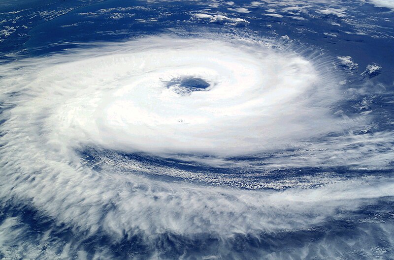
English: Before the year 2004, only two tropical cyclones had ever been noted in the South Atlantic Basin, and no hurricane. However, a circulation center well off the coast of southern Brazil developed tropical cyclone characteristics and continued to intensify as it moved westward. The system developed an eye and apparently reached hurricane strength on Friday, March 26, before eventually making landfall late on Saturday, March 27, 2004.
The crew of the International Space Station was notified of the cyclone and acquired excellent photographs of the storm just as it made landfall on the southern Brazilian state of Santa Catarina (the storm has been unofficially dubbed “Cyclone Catarina”). Note the clockwise circulation of Southern Hemisphere cyclones, the well-defined banding features, and the eyewall of at least a Category 1 system. The coastline is visible under the clouds in the upper left corner of the image.
Français : Avant 2004, aucun cyclone n'a jamais été observé dans l'Atlantique sud. Cependant, au cours du mois de mars 2004, un système dépressionnaire situé loin au large du Brésil a développé toutes les caractéristiques d'un ouragan tout en se déplaçant vers l'ouest. Le 26 mars, l'ouragan forme un œil bien défini ce qui correspond au niveau Cyclone. Le 27 mars 2007 au soir, il atteint les côtes brésiliennes.
L'équipe de la station spatiale internationale, informée du développement de ce cyclone inhabituel, a pu prendre de belles photos du cyclone juste au moment ou il a touché terre dans l'état brésilien de Santa Catarina (D’où son nom officieux de Cyclone Catarina. Le cyclone présente sur cette photo un œil bien défini, et tourne dans le sens des aiguilles d'une montre. La côte est visible en haut à gauche de l'image.
Թվական Taken on 26 Մարտ 2004
Աղբյուր

NASA

Սա խմբագրված պատկեր է, որը համեմատ բնօրինակին ենթարկվել է թվային մշակման։ Փոփոխությունները՝ Increased contrast; decreased brightness; adjusted color balance in favor of blues and whites; removed large black splotches in several locations: Խմբագրել է Tomf688 մասնակիցը։

Հեղինակ Astronaut photograph ISS008-E-19646 was taken March 7, 2004, with a Kodak DCS760 digital camera equipped with an 50-mm lens, and is provided by the Earth Observations Laboratory, Johnson Space Center.
Իրավունքներ
(Նիշքի վերաօգտագործումը)
Public domain Այս նիշքը հանրության սեփականության է պատկանում, քանզի այն ստեղծվել է ՆԱՍԱ-ն։ ՆԱՍԱ-ի հեղինակային իրավունքների մասին քաղաքականությունը նշում է, որ «ՆԱՍԱ-ի նյութերը հեղինակային իրավունքներով պաշտպանված չեն, միթե այդպես նշված լինի»։ (Տե՛ս Template:PD-USGov, ՆԱՍԱ-ի հեղինակային իրավունքների քաղաքականության մասին էջը կամ ՋեյՓիԷլի պատկերների օգտագործման մասին քաղաքականությունը
Զգուշացումներ՝:
This file was reviewed on 24 Մայիս 2011 by the administrator or trusted user Jappalang (talk), who confirmed the Public Domain status on that date.
Այլ մեկնակերպներ

Derivative works of this file:

Այս պատկերը կամ տեսագրությունը մտցրած են одного из исследовательских центров Национального управления США по аэронавтике и исследованию космического пространства (NASA)под идентификатором (Photo ID): ISS008-E-19646.

Эта пометка не указывает на правовой статус данной работы. Пометка о правовом статусе по-прежнему необходима. См. подробнее правила лицензирования Викисклада.

Captions

Add a one-line explanation of what this file represents

Items portrayed in this file

պատկերված

26 Մարտի 2004

checksum անգլերեն

22fa4adf15ddb6ea8382256b3bbda28b31f1c8f3

data size անգլերեն

1 063 189 Բայթ

2004 փիքսել

3032 փիքսել

captured with անգլերեն

Kodak DCS 760 անգլերեն

Նիշքի պատմություն

Մատնահարեք օրվան/ժամին՝ նիշքի այդ պահին տեսքը դիտելու համար։

Օր/ԺամՄանրապատկերՕբյեկտի չափըՄասնակիցՄեկնաբանություն
ընթացիկ00:56, 11 Սեպտեմբերի 200600:56, 11 Սեպտեմբերի 2006 տարբերակի մանրապատկերը3032 × 2004 (1,01 ՄԲ)Tomhigher res
13:10, 8 Սեպտեմբերի 200513:10, 8 Սեպտեմբերի 2005 տարբերակի մանրապատկերը1000 × 662 (321 ԿԲ)Tom
06:27, 24 Օգոստոսի 200506:27, 24 Օգոստոսի 2005 տարբերակի մանրապատկերը1000 × 662 (321 ԿԲ)Tom{{PD-USGov-NASA}} http://eol.jsc.nasa.gov/sseop/images/EO/highres/ISS008/ISS008-E-19646.JPG Only two tropical cyclones had ever been noted in the South Atlantic Basin, and no hurricanes. However, a circulation center well off the coast of southern Brazi

Հետևյալ 2 էջերը հղվում են այս նիշքին՝

Նիշքի համընդհանուր օգտագործում

Հետևյալ այլ վիքիները օգտագործում են այս նիշքը՝

Տեսնել այս նիշքի ավելի համընդհանուր օգտագործումը:

Մետատվյալներ